Leavenworth, Kansas
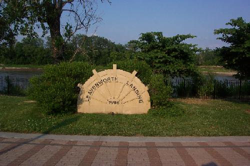
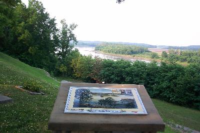
Leavenworth Landing
"Turkeys are plenty on the Shore G. Dwyer informs me that
he Saw PueCanns (pecan) trees on S.
S. yesterday. great quantities of raspburies an Grapes... pass
a run on the L.
S. a Butifull extensive Prarie, two Islands just above called (Isle
des Parques) or Gield Islands" July
1st ,
Leavenworth,
Kansas provides excellent views of the Missouri River that are reminiscent
of what Lewis and Clark observed on their journey. The
site of the Leavenworth Landing allows students to get close to its broad,
swift moving current. A museum on Fort Leavenworth and marked sites
on the fort provide a glimpse into what life was like for the pioneers
who followed in the wake of the Lewis and Clark expedition. In addition,
there are several markers and waysides of the expedition that provide a
visual image for the text of the journals.
The best assignment in this area is for students
to bring copies of the journals from July 1st to July 3rd with them to
read and compare to what they see today. The River Front park in
the city of Leavenworth, and the area along Hancock Hill on Fort Leavenworth
provide good views and displays that match the descriptions
in the journals.
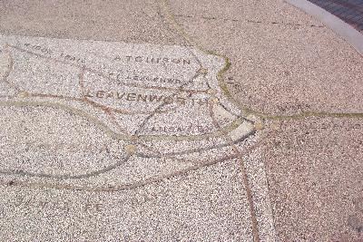
A map of the leavenworth and Fort Leavenworth area
is found at http://www.lvks.org/map.html
Leavenworth Landing
 River Front park provides a broad walkway that allows
students to walk along the banks of the river. The benches by the
river provide excellent spots for journaling activities, or eating lunch.
(You will pass fast food places as you come through town on Hwy 7 if you
wish to stop and eat.) A raised stone map shows the trails heading west
with a steady flow of immigrants who followed in the wake of Lewis and
Clark.
River Front park provides a broad walkway that allows
students to walk along the banks of the river. The benches by the
river provide excellent spots for journaling activities, or eating lunch.
(You will pass fast food places as you come through town on Hwy 7 if you
wish to stop and eat.) A raised stone map shows the trails heading west
with a steady flow of immigrants who followed in the wake of Lewis and
Clark.
River Front Park is easily accessible by traveling
north on Hwy 7 through town and turning right on Cherokee. There is ample
parking for buses just steps away from the park.
This is an excellent photo and journal opportunity
for students who can later add these images to their journals. It
is also a good spot for sketching or map making.
Fort Leavenworth
Fort Leavenworth is an active military base,
that is layered in
history. There are markers to the Santa Fe Trail, military history,
and a monument to the Buffalo
Soldiers.
It also has a Frontier
Army Museum that can give your students an overview of what happened
after Lewis and Clark passed through here. In addition, the museum
has assembled a corps of living
historians who will be available for encampments and presentations.
Moreover, regularly scheduled encampments and presentations will take place
at the Frontier Army Museum. Contact (913) 684-3191/3767 or e-mail
web-dptm-museum@leavenworth.army.mil
There are the markers on the fort commemorating the
journey of Lewis and Clark. These are found along Hancock Hill, a
short walk from the Frontier Army Museum. One of the first
is the newly placed marker by the Daughters of the American Revolution.
It overlooks a stretch of Missouri River.
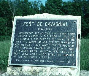
On the site now occupied by Fort Leavenworth, stood
Fort
de Cavagnial, a French outpost. It was abandoned
by 1804 as Clark notes "the French formerly had a fort at this place, to
protect the trade of this nation..." In this same area stood a Kansas
Indian Village, also described by Clark on his July
the 2nd 1804 entry.
A wayside marker nearby gives an artist rendition
of the area at the time of Lewis and Clark with Fort de Cavagnial represented.
The most impressive physical trace left on the fort's
grounds is the wagon cut that travelers along the Santa Fe trail.
To reach this well marked spot, travel directly down the main street of
the Fort until you reach the Untied States Disciplinary Barracks.
Follow the road to the right that leads to the river and you will find
the cut.